
5. Arthur's Way, Oughterard
From Oughterard To Oughterard Cemetary
INTRODUCTION
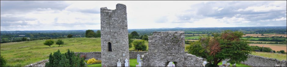
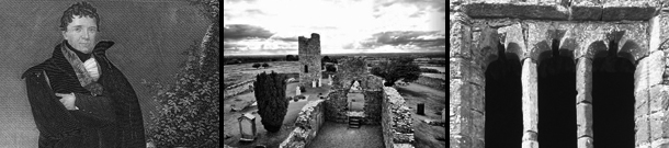
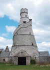
Oughterard (in Irish Uachtar Árd) means high place. It is an apt description. The relatively easy climb to the cemetery is deceptive; when you reach the open ground in the graveyard, you are rewarded with remarkable views of the plain of Kildare and a broad sweep of Leinster to the west, and the Dublin and Wicklow Mountains stretching away to the south. From the top of what remains of the round tower, one can see the Head of Howth in neighbouring county Dublin. The site is a National Monument.
EARLY HISTORY
The site is of considerable importance for its archaeology, history and architecture. Saint Bríga (Brigid) is said to have founded the monastery in the 6th century. Her feast day is January 21. She is a contemporary of the better-known Saint Brigid, the patron saint of Kildare. The road towards Lyons Hill was part of the ancient 'slí' route network that traversed the country. These often followed higher ground and gravel ridges (eskers) to avoid bogs. According to research, this is part of the Slí Dála, or 'Way to the Assembly'. It would have led south into Munster from the Hill of Tara - an important royal seat in Celtic Ireland.The site itself is surrounded by a rough coursed stone wall, and contains the ruins of a church and round tower. The current church may date back to 1350, and was most likely built on the site of an original, early-Christian monastic church. The original monastery was under the patronage of a local powerful clan who made nearby Lyons Hill their base (Lyons Hill was the royal seat for the Kingship of Leinster at times between 750 and 1050 AD). In early Irish manuscript records (the Annals), the Vikings under Sitric Silkenbeard burnt the monastery down in 995. A revenge of sorts of was meted out by Brian Ború in the Battle of Glenn Máma in 999, when the soon-to-be Irish king defeated the combined forces of Sitric and Leinster at a site identified as a valley behind Lyons Hill. Oughterard became a Royal Manor and Borough in the 12th Century. The ruined castle in the adjoining field to the west dates back to Anglo-Norman times, circa 1300. Records show that much of this area was given by Diarmuid MacMurrough, King of Leinster, to Richard de Clare, better known as Strongbow, as part of a dowry, following the marriage of Strongbow to Aoife, Diarmuid's daughter.
THE SITE TODAY
The church is now entered through one of the windows, as both original doorways serve as mausoleums. The 8th century round tower is one of five in Co. Kildare, and is composed of uncoursed, spalled limestone. The doorway and arched window are of granite. The tower is 9.6 metres from lowest ground to highest point. It sits 2.65 metres above the present ground level, though it is likely that the ground level has been raised since the tower was originally built; typically, doorways to round towers were always placed well away from the ground to provide protection against attack. The single window at the second storey level faces south, echoing the design of the doorway.HISTORICAL CONNECTIONS
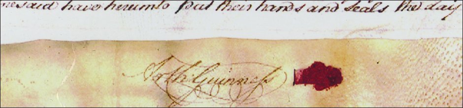
Renowned Irish political campaigner Daniel O'Connell fought a duel with John D'Esterre in an adjoining field, in 1815. D'Esterre died as a result of his wounds, an incident O'Connell regretted for the rest of his life. A boulder commemorating the event was removed, but was re-established in 2007. In about 1722-24, Richard Guinness married Elizabeth Read, daughter of William and Catherine Read of Oughterard. William Read was a tenant farmer at Oughterard who bought a licence to sell ale in 1690, which meant that he probably brewed his own beer. As he lived near the main road, (until the construction of the turnpike road in the adjoining valley in 1729, Oughterard was situated on the main road from Dublin to Limerick and Cork) William Read most likely set up a booth alongside it, selling ale to passing trade to increase his farm income. William and his wife Catherine are buried at Oughterard as is their daughter Elizabeth Guinness, née Read.Opinion is divided over the date and birthplace of renowned brewer, Arthur Guinness, sometime in 1724, or early 1725. Some suggestions place the event in the surrounding locality of Ardclough, possibly in the Read homestead, whilst others point to nearby Celbridge, where his parents lived in 1725. There is no doubt that he died in 1803, and his remains lie within the ruins of the church, along with his wife and other family members, including his wife Olivia and brother Richard. We ask that you kindly respect the site, and the remains of those found within. The cemetery is still in use to this day, and is carefully maintained by the local community.
ARTHUR'S WAY, OUGHTERARD
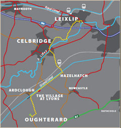
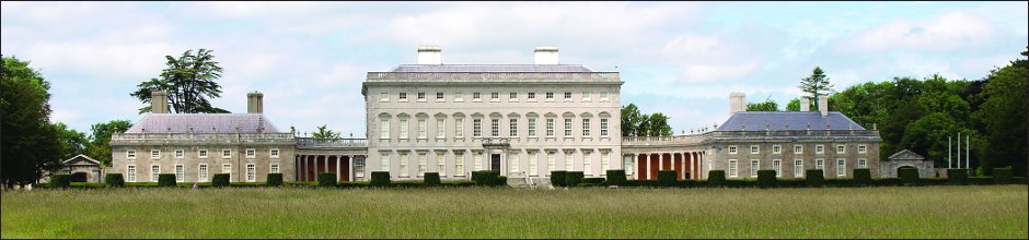
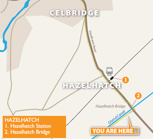
Arthur's Way is a heritage trail across northeast County Kildare that follows in the footsteps of Arthur Guinness. In just 16 km, it links many of the historic sites associated with Ireland's most famous brewers - the Guinness family. Visitors are invited to explore Celbridge - where Arthur spent his childhood, Leixlip - the site of his first brewery and Oughterard graveyard - Arthur's final resting place near his ancestral home. The trail rises gently from the confluence of the Liffey and Rye rivers at Leixlip to the Palladian Castletown House estate and onto Celbridge. It then departs the Liffey Valley to join the Grand Canal at Hazelhatch. The grassy towpaths guide visitors past beautiful flora and fauna and the enchanting Lyons Estate. At Ardclough, the route finally turns for Oughterard which offers spectacular views over Kildare, Dublin and the Province of Leinster.Please note: the graveyard at Oughterard is maintained by the local community and is still in use. Please be considerate when locking bicycles or parking cars, and be respectful of the monuments and headstones within.
Arthurs Way
 RECOMMENDED ROUTE
POINTS OF INTEREST & DISTANCES
STAGE 1: Arthur Guinness Square, Leixlip
towards...
STAGE 2: Celbridge Main Street
towards...
STAGE 3: Hazelhatch Bridge
towards...
STAGE 4: Lyons Estate
towards Oughterard
![]()
LENGTH: 16km approx.
TIME: 3-3.5 hours walking; 1-1.5 hours cycling
GRADE: Easy. Generally flat with good surfaces. Inclines at Old Hill, Leixlip and
Ardclough. Mix of footpaths, tracks, roads and canal towpath. Suitable
for family groups. Normal outdoor footwear can be worn.
Arthur's Way is a waymarked linear route which can be enjoyed in either direction.
 Keep an eye out for the Arthur's Way information boards, fingerposts and marker posts to help keep you on track
PUBLIC TRANSPORT
To and from LEIXLIP:
Dublin Bus - all 66 routes
Irish Rail - Maynooth Suburban Line
To and from CELBRIDGE:
Dublin Bus - all 67 routes
Irish Rail - Portlaoise Line
www.dublinbus.ie
www.irishrail.ie
www.transportforireland.ie

Log on to the website to get more
information on the route, including
MAPS and LEAFLETS, and an AUDIO GUIDE.
www.ArthursWay.ie