1. Arthur's Way, Leixlip
From Leixlip To Celbridge
 tanding here, you are only a couple of hundred metres from the site of the original Guinness brewery, where the world famous entrepreneur began his life's work. Born in 1725, Arthur Guinness grew up in nearby Celbridge, County
Kildare - not far from his ancestral home. As a young man, Arthur worked as a land agent
until the death of his wealthy employer prompted changes to his prospects. Within a few
years, Arthur had arrived in Leixlip to develop his business interests in brewing and
property which would give him the confidence to move eastwards to Dublin. And the rest,
as they say, is history!
tanding here, you are only a couple of hundred metres from the site of the original Guinness brewery, where the world famous entrepreneur began his life's work. Born in 1725, Arthur Guinness grew up in nearby Celbridge, County
Kildare - not far from his ancestral home. As a young man, Arthur worked as a land agent
until the death of his wealthy employer prompted changes to his prospects. Within a few
years, Arthur had arrived in Leixlip to develop his business interests in brewing and
property which would give him the confidence to move eastwards to Dublin. And the rest,
as they say, is history!
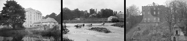
The Original Brewery Site
Left: The original brewery site at Castleview is marked in
red. The River Liffey was traversed by a weir. The mill race
shown to the bottom left of the map extended down to a
mill. Some of the mill buildings still exist today at the end
of Mill Lane, though the mill race has largely vanished
Right: The mill buildings on the River Liffey, pictured circa 1900
Below: Leixlip Castle and Boathouse, viewed roughly from the site
of the original 'Castleview' brewery
(Originally published between 1880-1900. © National Library of Ireland)
Above: The weir on the River Liffey, now dismantled.
St. Mary's Church is visible in the background
(Originally published between 1865-1914.
© National Library of Ireland)
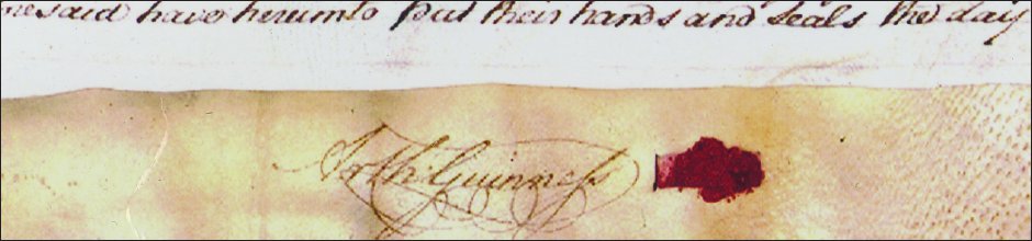
Below: Part of the 1759 lease,
showing the famous signature
that is synonymous with the
brand worldwide
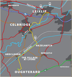
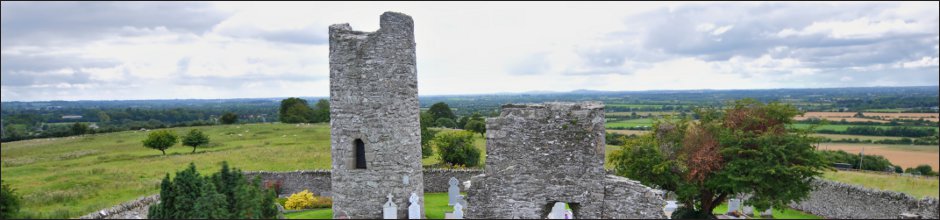
Arthur's Way is a heritage trail across northeast County Kildare that follows in the footsteps of Arthur Guinness. In
just 16 km, it links many of the historic sites associated with Ireland's most famous brewers - the Guinness family.
Visitors are invited to explore Celbridge - where Arthur spent his childhood, Leixlip - the site of his first brewery and
Oughterard graveyard - Arthur's final resting place near his ancestral home.
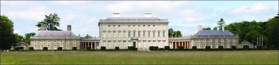
The trail rises gently from the confluence of the Liffey and Rye rivers at Leixlip to the Palladian Castletown House
estate and onto Celbridge. It then departs the Liffey Valley to join the Grand Canal at Hazelhatch. The grassy towpaths
guide visitors past beautiful flora and fauna and the enchanting Lyons Estate. At Ardclough, the route finally turns for
Oughterard which offers spectacular views over Kildare, Dublin and the Province of Leinster.
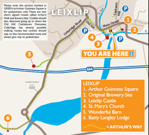
Arthurs Way
 RECOMMENDED ROUTE
POINTS OF INTEREST & DISTANCES
STAGE 1: Arthur Guinness Square, Leixlip
towards...
STAGE 2: Celbridge Main Street
towards...
STAGE 3: Hazelhatch Bridge
towards...
STAGE 4: Lyons Estate
towards Oughterard
![]()
LENGTH: 16km approx.
TIME: 3-3.5 hours walking; 1-1.5 hours cycling
GRADE: Easy. Generally flat with good surfaces. Inclines at Old Hill, Leixlip and
Ardclough. Mix of footpaths, tracks, roads and canal towpath. Suitable
for family groups. Normal outdoor footwear can be worn.
Arthur's Way is a waymarked linear route which can be enjoyed in either direction.
 Keep an eye out for the Arthur's Way information boards, fingerposts and marker posts to help keep you on track
PUBLIC TRANSPORT
To and from LEIXLIP:
Dublin Bus - all 66 routes
Irish Rail - Maynooth Suburban Line
To and from CELBRIDGE:
Dublin Bus - all 67 routes
Irish Rail - Portlaoise Line
www.dublinbus.ie
www.irishrail.ie
www.transportforireland.ie

Log on to the website to get more
information on the route, including
MAPS and LEAFLETS, and an AUDIO GUIDE.
www.ArthursWay.ie