
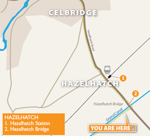
3. Arthur's Way, Hazel Hatch
From Hazel Hatch To Lyons Estate
INTRODUCTION
This stretch of Arthur's Way introduces you to the Grand Canal. This feat of 18th Century Victorian engineering allowed the Guinness brewery in Dublin to expand its operations. These days, what was once a business enterprise is now a valuable amenity for walkers, cyclists, anglers, boating enthusiasts and nature lovers.
THE GUINNESS CONNECTION
By 1759, the Guinness brewery had moved from Leixlip to its current Dublin premises at James's Gate. By that stage, the Grand Canal had been under construction for about three years, and had reached Sallins in Co. Kildare; a distance of 30 kilometres. The canal played a vital role in the early development of the business, not least as the Grand Canal at that time terminated in a basin at James's Street beside the brewery. All breweries need plentiful supplies of grain and fresh water, not to mention other important raw materials, such as fuel and timber for the coopers.The brewery was able to use the fresh water of the canal (and the Poddle River) for brewing, and bring in supplies of grain by barge, then load up the barges to take the wooden casks of beer into the midlands for sale. In time, the brewery established its own purpose-built canal basin, and even had its own railway system to get its product to the nearby quays for shipment overseas. It left the barge transport in the hands of the Grand Canal Company.
The old Dublin story, told in jest by local wags to visitors, was that Guinness was made with the discoloured Liffey water that flowed past the quays in the heart of the capital. Instead, the famous beer was originally made from canal water fed largely from pure springs bubbling up in the heart of Kildare, at Pollardstown Fen, near Newbridge.
THE MILLTOWN FEEDER
Pollardstown Fen is crucial to the life of the Grand Canal. Water enters the canal from this fen via the Milltown Feeder at the summit point - the highest point of the canal network. All canals, being man-made constructions, require a constant supply of water. This ensures that the levels are constantly 'topped up' and the lock systems work. Canals may appear to be flat stretches of water, but as they travel through the countryside, they rise and fall with the contours of the land. Note for example that this stretch of the canal is higher than the surrounding land. Engineers have always tried to follow the most level routes, and the midlands of Ireland are relatively flat (bogs were to prove a considerable and expensive obstacle). Even so, the Main Line of the canal (131 kilometres) required 43 locks to get boats from Dublin to the Shannon River, the highest point being 85 metres above sea level.
There are several branches off the main line, including the Naas and Corbally Branch, the Barrow Line and the Kilbeggan Branch. The Milltown Feeder is the canal's main supply, built in the 1780s, and it provides enough water to fill ten Olympic-size swimming pools each day! This is made possible by dozens of springs which feed the fen - water that is carried there from the Curragh Aquifer, a vast underground store of water over 200 km2, found within sand and gravel laid down during the last Ice Age. To this day, water is still taken from the canal for the James's Gate Brewery (filter beds can be found near the Eighth and Fifth Locks). However, this water is used for washing, not brewing. In a slightly ironic twist, Guinness is now made from water abstracted in the Wicklow Mountains; much the same water that the million or more citizens of Dublin enjoy each day. And the same water that flows down through the Sally Gap, into Poulaphouca Reservoir, on down through Kildare County before reaching its destination in Dublin Bay, as the River Liffey. Or, to co-opt a phrase from the company's own marketing, there's nothing magic about the water per se... the key ingredient is inspiration! Sadly, the canal no longer goes into James's Gate Brewery. Indeed, the section that exists today from Inchicore to the Grand Canal Docks was considered to be a branch line. It is known as the Circular Line, built in 1790, with seven locks. The old line to the brewery and the City Basin fell into disrepair and was considered something of a hazard by locals. In 1974, it was filled in.
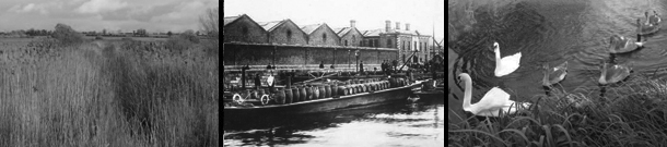
NATURE ON THE GRAND CANAL
Despite its man-made origins, the canal and its towpaths are rich with wildlife, particularly in summer. The stretch is popular with anglers, and even a casual stroll is usually rewarded with a glimpse of Mute Swans, Mallards, Coots or Moorhens. Swallows skim the surface, and dragonflies hunt for insects. Buzzards are sometimes seen hunting overhead.
In season, you may find the yellow blooms of water lilies on the surface, with Marsh Marigold and Flag Iris in the margins, amongst the reeds, rushes and tall grasses. The hedgerows are bursting with life; in particular look out for Hawthorn, Blackthorn, Dog Rose and Spindle. Bats take over insect-hunting
duties in the evenings but you need to be up early if you want to see Foxes, Badgers, Stoats and Otters that also live along the canal. Under the surface, amongst the milfoils, pondweeds and Mare's Tail, the canal teems with life. Most of it is made up of tiny, invertebrate insect life, but there are larger species too, such as Swan Mussels and Crayfish. Roach, Bream, Tench and Pike are just some of the coarse fish on offer.
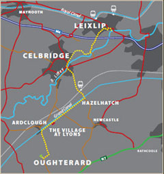
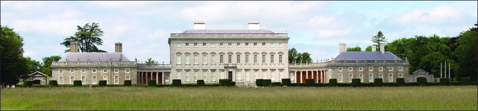
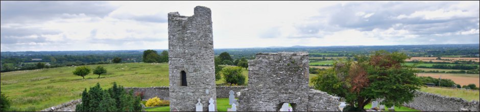
Arthur's Way is a heritage trail across northeast County Kildare that follows in the footsteps of Arthur Guinness. In just 16 km, it links many of the historic sites associated with Ireland's most famous brewers - the Guinness family. Visitors are invited to explore Celbridge - where Arthur spent his childhood, Leixlip - the site of his first brewery and Oughterard graveyard - Arthur's final resting place near his ancestral home. The trail rises gently from the confluence of the Liffey and Rye rivers at Leixlip to the Palladian Castletown House estate and onto Celbridge. It then departs the Liffey Valley to join the Grand Canal at Hazelhatch. The grassy towpaths guide visitors past beautiful flora and fauna and the enchanting Lyons Estate. At Ardclough, the route finally turns for Oughterard which offers spectacular views over Kildare, Dublin and the Province of Leinster.
Please note: much of the Hazelhatch Road has footpaths and some cycle paths. The Bridge at Hazelhatch over the canal is very narrow. Please use caution when crossing.
Arthurs Way
 RECOMMENDED ROUTE
POINTS OF INTEREST & DISTANCES
STAGE 1: Arthur Guinness Square, Leixlip
towards...
STAGE 2: Celbridge Main Street
towards...
STAGE 3: Hazelhatch Bridge
towards...
STAGE 4: Lyons Estate
towards Oughterard
![]()
LENGTH: 16km approx.
TIME: 3-3.5 hours walking; 1-1.5 hours cycling
GRADE: Easy. Generally flat with good surfaces. Inclines at Old Hill, Leixlip and
Ardclough. Mix of footpaths, tracks, roads and canal towpath. Suitable
for family groups. Normal outdoor footwear can be worn.
Arthur's Way is a waymarked linear route which can be enjoyed in either direction.
 Keep an eye out for the Arthur's Way information boards, fingerposts and marker posts to help keep you on track
PUBLIC TRANSPORT
To and from LEIXLIP:
Dublin Bus - all 66 routes
Irish Rail - Maynooth Suburban Line
To and from CELBRIDGE:
Dublin Bus - all 67 routes
Irish Rail - Portlaoise Line
www.dublinbus.ie
www.irishrail.ie
www.transportforireland.ie

Log on to the website to get more
information on the route, including
MAPS and LEAFLETS, and an AUDIO GUIDE.
www.ArthursWay.ie