4. Arthur's Way, Lyons Estate
From Lyons Estate To Oughterard
INTRODUCTION
Arthur's Way continues along the Grand Canal, and takes you into the heart of north Kildare. As you leave behind Hazelhatch and head south-west, you will get glimpses of Lyons Hill amongst the foothills of the Dublin Mountains.
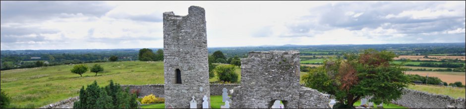
LYONS
Lyons (in Irish Liamhan) means ‘elm tree’. Lyons village has an interesting and almost Phoenix-like history. The first settlements date back to the Iron Age when Kings of Leinster ruled from the nearby hilltop, Lyons Hill, or Cnoch Liamhna, the hill of the elm. The Uí Dúnchada clan maintained considerable control in the area, even with the arrival of the Anglo-Normans. However, Lyons manor was to pass to the Tyrells and in 1271 to the Aylmer family. The name is synonymous with this area, and the keen observer may have noticed that your journey from Hazelhatch takes you past Aylmer’s Bridge.By the early 17th Century, a town and castle could be found at Lyons, but this was destroyed in the Irish Rebellion of 1641. Over a hundred years later, with relative peace restored and the Industrial Revolution in full swing, the Grand Canal arrived at the foot of Lyons Hill in 1763, with the construction of the 13th Lock. Construction of the Grand Canal took place between the mid and late 1700s, and was to become, prior to the railways, a vital link for commerce, stretching from Dublin to the Shannon, breathing new life into settlements such as Lyons.
THE VILLAGE HISTORY
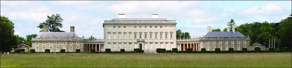
In 1786, construction of Lyons House began, courtesy of Dublin banker Sir Nicholas Lawless, and by the turn of the century, burgeoning barge traffic gave rise to a busy community of shops, a mill, a forge, hotel and barracks. In the mid-1800s, up to 90 barges a day were passing through this spot, bringing a variety of local produce to the capital city, from flour to stone quarried nearby at Boston Hill, near Ardclough. It helped that Lyons was the nearest overnight stop to Dublin for the slow-moving barges which typically travelled at about three miles per hour.However, the industrial revolution that had given birth to the canal network was to follow up with another innovation: steam engines and the railway. In 1850, the Dublin to Galway rail service began operations, spelling the slow but inexorable end to the commercial life of the canals. The mill burned down in 1903, boat traffic ceased in 1960, and Lyons House was sold in 1962, and by that stage, the village was all but a ghost town. The house was bought by Michael Smurfit in 1990, but it wasn’t until pioneer aviation businessman Tony Ryan took over the house and estate and lavishly restored them between 1999 and 2007 that life again came to Lyons. (Visit www.villageatlyons.com for more).
FAMOUS NAMES, FAMOUS PLACES
As we have discovered on our journey in Arthur’s footsteps, this area of Kildare has witnessed many key events in Irish history, from ancient Kings of Leinster, folk hero Brian Ború’s lifelong battle with the Vikings, and the coming of the Anglo-Normans. In later years, prominent families would put down their roots in the locality - names such as Lawless and Aylmer - and in 1798, the first shots of the ill-fated Rising (the rebellion against British rule) were fired in Kildare. William Aylmer was one of the leaders, and he had a most colourful life. Following exile from the failed rebellion, he spent twenty years with the Austrian army, before sailing to Venezuela to assist Simón Bolívar’s struggle for independence from Spain. He died in Jamaica in 1820.These were interesting times for a prominent businessman such as Arthur Guinness. His position in Dublin society put him in touch with many of the prominent movers behind the attempts at Irish independence. But he always kept an eye on business. In 1782, he welcomed Henry Grattan’s decision to impose taxes on English imported ale. These were valuable steps in the progress of the brewery. That decade also saw the setting up of the Bank of Ireland (1783), and the building of the Four Courts, the Post Office (near Dublin Castle) and the Customs House. It was something of a boom time for business, but even then, investments had to be made wisely, as fortunes were easily lost. Arthur, despite his heavy reliance on the Grand Canal, never invested in it as a business opportunity. A wise move!
Five years after the Rising, United Irishman, Robert Emmet, led a Kildare-based rebellion. This too failed. What Arthur Guinness made of these uprisings we cannot say for certain, though his life is examined in great detail in Patrick Guinness’s excellent book, ‘Arthur’s Round’. Politically, he would have favoured Catholic Emancipation, but may not have favoured complete Irish independence. Whilst Arthur lived to see the 1798 Rising, he died six months before Emmet’s attempts, passing away on January 23rd, 1803. One of the victims of that second rebellion, Viscount Kilwarden, is buried at Oughterard.
Arthur’s life is entwined with this part of Kildare. It would not have escaped him that his grandfather, William Read, brewed and sold beer at the foot of Ardclough where, in Arthur’s own lifetime, he was to witness the construction of the canal that passed through the heart of his homeland; the very canal that was to be the lifeblood of his burgeoning business. And from Oughterard, one can glimpse not just the canal, but his childhood haunts, the site of his first brewery, and the plain of Kildare and the Liffey that winds its way to Dublin. It is fitting his final resting place looks out over these important landmarks. Our final leg takes us on a journey Arthur would have found familiar; up Boston Hill to Oughterard.
ARDCLOUGH
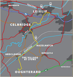
Arthur’s Way is a heritage trail across northeast County Kildare that follows in the footsteps of Arthur Guinness. In just 16 km, it links many of the historic sites associated with Ireland’s most famous brewers - the Guinness family. Visitors are invited to explore Celbridge - where Arthur spent his childhood, Leixlip - the site of his first brewery and Oughterard graveyard - Arthur’s final resting place near his ancestral home. The trail rises gently from the confluence of the Liffey and Rye rivers at Leixlip to the Palladian Castletown House estate and onto Celbridge. It then departs the Liffey Valley to join the Grand Canal at Hazelhatch. The grassy towpaths guide visitors past beautiful flora and fauna and the enchanting Lyons Estate. At Ardclough, the route finally turns for Oughterard which offers spectacular views over Kildare, Dublin and the Province of Leinster.Please note: once you leave the towpath at Henry Bridge, Ardclough, you are back on public road. There follows a long but reasonable climb up to Oughterard.
ARTHUR'S WAY
Keep an eye out for the Arthur’s Way information boards, fingerposts and marker posts. Arthur’s Way is a waymarked linear route which can be enjoyed in either direction.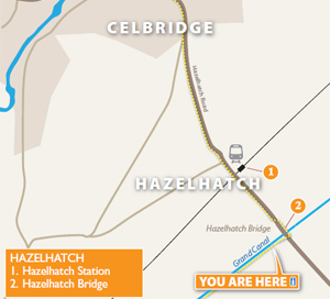
Arthurs Way
 RECOMMENDED ROUTE
POINTS OF INTEREST & DISTANCES
STAGE 1: Arthur Guinness Square, Leixlip
towards...
STAGE 2: Celbridge Main Street
towards...
STAGE 3: Hazelhatch Bridge
towards...
STAGE 4: Lyons Estate
towards Oughterard
![]()
LENGTH: 16km approx.
TIME: 3-3.5 hours walking; 1-1.5 hours cycling
GRADE: Easy. Generally flat with good surfaces. Inclines at Old Hill, Leixlip and
Ardclough. Mix of footpaths, tracks, roads and canal towpath. Suitable
for family groups. Normal outdoor footwear can be worn.
Arthur's Way is a waymarked linear route which can be enjoyed in either direction.
 Keep an eye out for the Arthur's Way information boards, fingerposts and marker posts to help keep you on track
PUBLIC TRANSPORT
To and from LEIXLIP:
Dublin Bus - all 66 routes
Irish Rail - Maynooth Suburban Line
To and from CELBRIDGE:
Dublin Bus - all 67 routes
Irish Rail - Portlaoise Line
www.dublinbus.ie
www.irishrail.ie
www.transportforireland.ie

Log on to the website to get more
information on the route, including
MAPS and LEAFLETS, and an AUDIO GUIDE.
www.ArthursWay.ie